FireSat Program Launches First Three Operational Satellites, Offering Advanced Wildfire Detection Amidst Escalating Fire Seasons

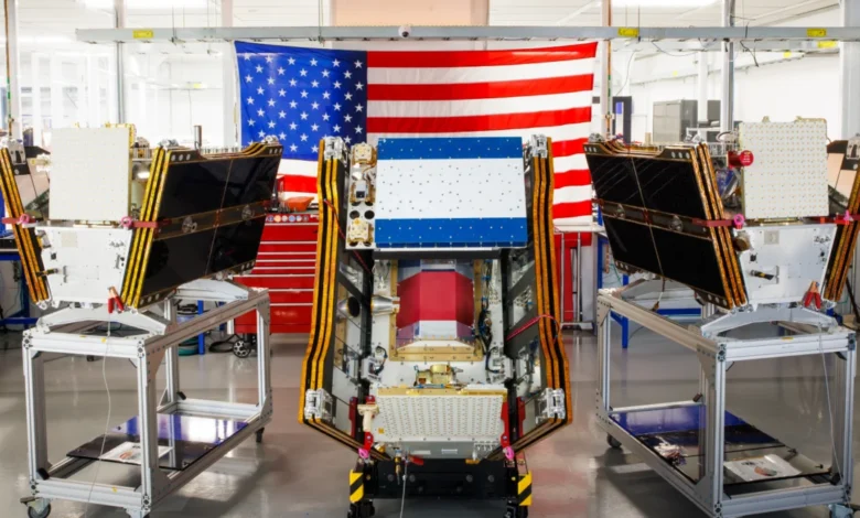
As vast plumes of smoke from an unprecedented wildfire season blanketed Canada and the United States in mid-July 2026, a new technological frontier in wildfire detection achieved a critical milestone: the successful deployment of the first three operational satellites for the Google-backed FireSat program. This initiative, spearheaded by the nonprofit Earth Fire Alliance, promises to revolutionize early wildfire detection, capable of identifying blazes as small as five by five meters, even through dense smoke and cloud cover, a capability that existing satellite systems often struggle to achieve.
The launch, which occurred on July 7, 2026, aboard a SpaceX Falcon 9 rocket from Vandenberg Space Force Base in California, signifies the transition of the FireSat constellation into "initial operational capability." This marks a significant step forward in the global effort to combat the growing threat of wildfires, exacerbated by climate change. Following a three-month calibration and testing period, these three microsatellites will commence providing critical data to fire agencies across the United States, Australia, and Europe, with a mission to cover every fire-prone region on Earth at least twice daily.
A New Era of Wildfire Monitoring
FireSat represents a groundbreaking development as the first satellite constellation specifically engineered for the purpose of wildfire detection. Developed by the California-based satellite manufacturer Muon Space, the program has garnered substantial financial backing, including over $15 million from Google and a significant $26 million commitment from the Bezos Earth Fund. This collective investment underscores the urgent need for advanced solutions to address the increasing frequency and intensity of wildfires worldwide.
The core innovation of the FireSat satellites lies in their multispectral imaging capabilities. These advanced sensors are designed to penetrate atmospheric interference, such as smoke and clouds, which often obscure ground-level conditions from conventional satellite views. This allows for the detection of nascent fires, including low-intensity blazes that might otherwise go unnoticed until they have grown into uncontrollable infernos.
The efficacy of this technology was previously demonstrated by a FireSat Protoflight satellite, launched in March 2025. During its testing phase, this prototype gathered over one million images, proving its ability to detect subtle heat signatures indicative of small, developing fires that were invisible to existing surveillance systems. This pre-operational success paved the way for the current deployment of the operational constellation.

Timeline of FireSat Development and Deployment:
- March 2025: Launch of the FireSat Protoflight satellite, demonstrating key detection capabilities.
- July 7, 2026: Successful launch of the first three operational FireSat satellites aboard a SpaceX Falcon 9 rocket.
- July-September 2026: Three-month testing and calibration period for the newly launched satellites.
- October 2026: Commencement of active data provision to fire agencies.
- By 2029: FireSat aims to provide hourly imagery updates for fire-prone regions globally.
- Early 2030s: Full deployment of the constellation, comprising over 50 satellites, enabling 20-minute global imagery coverage.
Early Adopters and Projected Impact
The Earth Fire Alliance has identified an initial cohort of "early adopter" organizations poised to leverage FireSat data starting in late 2026. These include prominent fire agencies in California and Colorado, alongside their counterparts in Australia and Portugal. The expansion of the constellation is envisioned to significantly enhance global wildfire response capabilities. By 2029, the program anticipates delivering near real-time imagery, with updates potentially every hour. Upon completion of the full constellation, expected in the early 2030s with over 50 satellites, this temporal resolution could shrink to as little as 20 minutes, offering unprecedented situational awareness.
The projected impact of this enhanced detection capability is substantial. The Earth Fire Alliance estimates that even an hourly revisit rate from the FireSat constellation could lead to significant savings, potentially exceeding $1 billion annually in fire damage costs. Furthermore, it could prevent the emission of approximately 22 million tons of carbon dioxide, while safeguarding an estimated 3,500 homes and 1.3 million acres of land from destruction.
The Role of AI in Wildfire Prediction and Mitigation
Google Research is set to play a crucial role in maximizing the utility of the FireSat data. The company plans to integrate its advanced Artificial Intelligence (AI) models to compare the operational satellite imagery with historical data. This analytical approach aims to achieve highly accurate identification of even the smallest fires and to refine predictive modeling for wildfire behavior. Google has publicly lauded the launch as a "tangible step forward in putting practical AI to work for climate resilience," highlighting the synergy between technological innovation and environmental protection.
The Interplay of AI, Data Centers, and Climate Change

While the FireSat program represents a significant advancement in climate resilience, it is important to acknowledge the broader context of AI development and its environmental footprint. The rapid expansion of AI technologies, particularly the training of large language models and complex AI systems, necessitates substantial computational power. This, in turn, drives demand for massive data centers, which consume vast amounts of electricity.
In the United States, a significant portion of this energy demand is being met by new natural gas projects. Projections suggest that the collective emissions from these data center-related projects could surpass 129 million tons of greenhouse gases annually. Google itself has acknowledged the challenges in sourcing sufficient clean energy to offset the escalating energy consumption of its data centers. In 2025 alone, the company reported a 37 percent increase in its electricity usage, largely attributed to its AI infrastructure buildout. This creates a complex dynamic where technological advancements aimed at mitigating climate impacts are simultaneously contributing to increased energy demands and potential emissions.
Challenges in Wildfire Management Amidst a Warming Planet
The FireSat program’s ability to detect fires early is a critical component of wildfire management, but it is not a panacea. Effective wildfire prevention and suppression require a multifaceted approach that includes robust funding for fire agencies, proactive ecosystem management such as prescribed burns, and efficient on-the-ground response capabilities. These efforts are becoming increasingly difficult due to the intensifying effects of global warming.
The recent wildfire seasons, particularly those experienced in Canada’s boreal forests, have demonstrated the inadequacy of traditional fire suppression methods when faced with the scale and intensity driven by climate change. The rapid spread of these blazes has forced the evacuation of thousands of individuals from First Nations communities and has generated hazardous air pollution affecting over 100 million people across Canada and the United States.
The Canadian Wildfire Crisis and Response
The wildfires that erupted in Canada’s boreal forests in the summer of 2026 served as a stark illustration of the escalating threat. These fires, burning with unprecedented size and ferocity, are directly linked to the warming climate caused by human-induced greenhouse gas emissions. Canada has experienced some of its most destructive wildfire seasons in recent years, with 2023 and 2025 ranking among the worst on record.

Senior research scientists have long predicted this scenario, noting that as the planet grows hotter and drier, forests become increasingly vulnerable, overwhelming conventional fire suppression strategies. Fighting fires in remote, largely uninhabited forest regions necessitates specialized aerial resources, including fixed-wing air tankers and heavy-lift helicopters capable of delivering fire retardants and transporting firefighting crews. However, the procurement and deployment of such assets are primarily the responsibility of individual Canadian provinces. In recent years, the demand for these resources has been so high that nearly all available aircraft have been deployed simultaneously. In response to this critical need, the Canadian government announced in May 2026 the leasing of 10 new aerial firefighting aircraft and two support assets to bolster nationwide response capacity.
As of July 17, 2026, the Canadian Wildland Fire Information System reported nearly 900 active wildfires across the country, with over 3,600 fires having burned more than 6.6 million acres to date. Many of these fires are classified as "out of control" and are being monitored rather than actively suppressed. This difficult decision is often made by fire agencies when faced with limited resources and the paramount concern for firefighter safety.
A Global Challenge Requiring Integrated Solutions
The deployment of the FireSat constellation represents a significant technological leap in the fight against wildfires. By providing earlier and more precise detection, these satellites offer a crucial tool for fire agencies to respond more effectively. However, the underlying causes of intensifying wildfire seasons – namely, climate change – demand broader societal and governmental action. This includes accelerating the transition to clean energy, investing in sustainable land management practices, and developing resilient infrastructure. The FireSat program, supported by significant investment and leveraging cutting-edge AI, stands as a testament to human ingenuity in confronting a global challenge, even as the wider implications of technological progress on the environment continue to be a critical area of focus. The future success in combating wildfires will likely depend on a synergistic approach, combining advanced detection technologies with robust on-the-ground resources and a global commitment to mitigating climate change.